
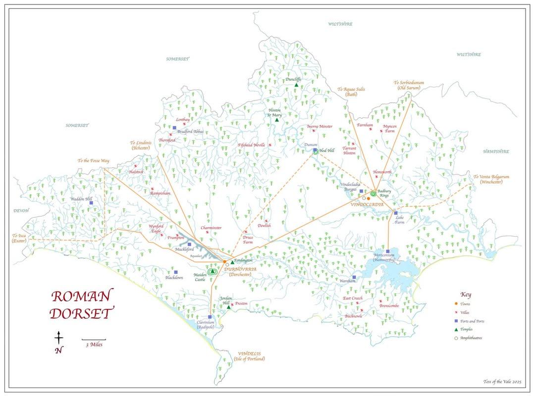
Map of Roman Dorset by Tess of the Vale, reproduced with permission. Higher resolutions of this map may be downloaded from this website. See also the map of hillforts
Some of the earliest Dorset Warlands are recorded as living or farming in the area around Lake Farm, west of Wimborne Minster and east of present day Corfe Mullen in Dorset. The Lake Farm area was the location of 'a major base of the Legio II Augusta during the conquest of the Durotriges and other tribes of South-West Britain in the mid 40s AD' (Source below). The fortress was only discovered in 1959.
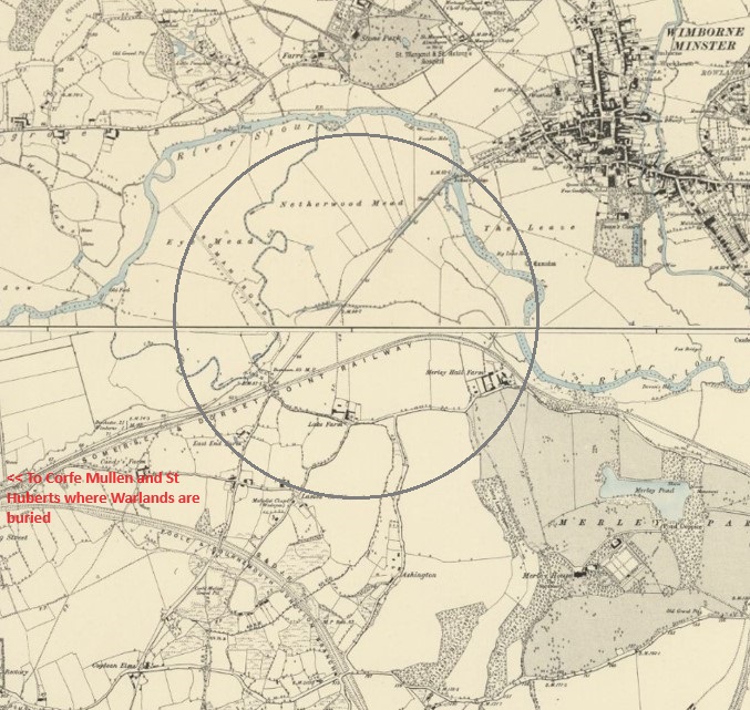
Extract from an 1887 Ordnance Map. The location of the present Lake Farm is shown in the bottom left of the circle. The original Roman road (not clear in this image) that leads from the bottom left of the map to the Lake Farm area is also visible. (Source: Ordnance Survey maps available online at the National Library of Scotland website.)
The content on this page comes from the following sources:
According to the paper by Russell et al, 'In the footsteps of Vespasian', a geophysical survey appears to suggest that the core part of the Roman fortress, 'a rectangular enclosure with rounded corners' was located in the yellow-bounded area of the Google map shown below. 'The main gate of the fortress, the porta praetoria was oriented to face west-north-west'. There were also other gates on the other sides. (Source: Russell et al, p2)
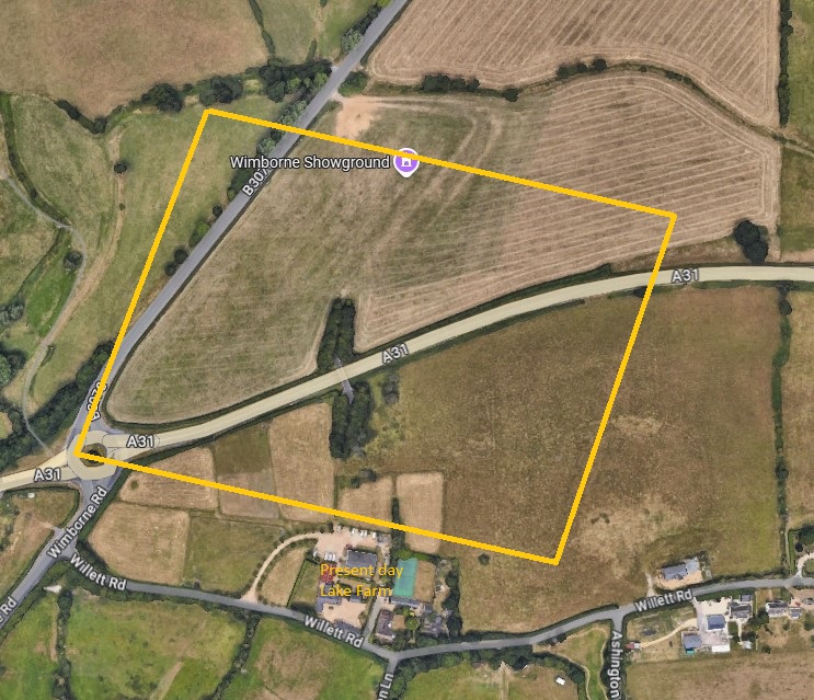
The approximate location of the Roman fortress (based on the map in the 'Foosteps of Vespasian' paper), and the location of the present-day Lake Farm
Archaeological evidence suggested that the fortress was constructed over two likely periods (but also see below for timings).
One of these two was a 'vexillation fortress', defined as a 'smaller', temporary camp used to house a subdivision of a legion or a composite military unit of between 2000 and 3000 men called a vexillation.
Excavation in the late 1970s by I Horsey (Archaeological Officer, Poole) found 'evidence of a rampart around the encampment, surrounded by a defensive ditch, with industrial activity outside that was discovered. Inside the rampart was a row of pits probably used for dumping refuse, and near this was part of a perimeter road which probably ran around the edge of the camp, which may have covered 20 or 30 acres. Evidence of timber built barrack blocks opening out into the centurion's quarters and the remains of what may have been administrative buildings near the centre of the site were also found. Finds included pottery, fragments of armour plating such as hinges, buckles and bronze hooks, plus a lead-lined tank set into a massive clay foundation, the purpose of which is unknown. It is unlikely that the site will ever be fully excavated due to its vast size.' (Historical England Research Records)
According to Norman Field's paper, Vespasian may have chosen this location because he was able to control movement through the natural gap that later gave Corfe its name. (Corfe comes from the same Anglo-Saxon root as 'carve' and meant a 'pass'.). Earlier travellers (on foot) would have had to by-pass a dense zone of trees and move down past the site of the later parish church, where the going was easier and the trees thinned out near the river - an obvious 'corfe' or gap, with good arable soil on a low terrace of valley gravel. Field also noted that the river Stour provided both a natural barrier and a means for supplies to be brought up from the deep-water anchorage off the Hamworthy peninsula, not far to the south. To that end, the first road was soon built, single-width to begin with, connecting harbour and the Roman base (as can be seen in the old map above). (Field)
The Romans built roads extending to and from the Lake fortress. These include roads running north-west to Badbury and on to Hod Hill (where a smaller Roman fort was installed), and north-east towards Winchester, and roads that passed through lower and upper Corfe Mullen, connecting Lake with Dorchester and Wareham. The early Roman road that ran through upper Corfe Mullen was the predecessor to the present Wareham road. (Field)
According to Russell et al, earlier studies into the Roman military strategy were influenced by a short section in Suetonis' Lives of the Twelve Caesars' in which it was stated that Vespasian 'fought the enemy on thirty occasions'.

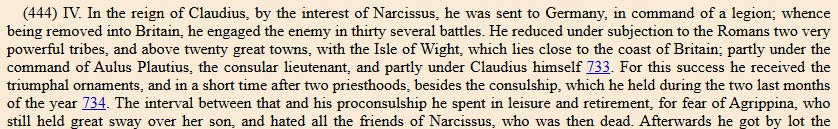
The original Latin and English translation of the section of Suetonis' book
Fighting was formerly believed to include attacks on all the hillforts in the region and the eventual suppression of the Durotriges. However, Russell et al suggest that many of these hillforts may have already been abandoned - 'there is unfortunately no evidence that any of the hillforts of Dorset were military active during the first century AD'. (Russell et al, p 5)
Instead, Russell et al state, based on the archaeological evidence, that the Durotriges appear to have had 'relatively dispersed communities living in individual, lightly enclosed farmsteads'. There may have been 'a prolonged period of armed resistance' but nothing in the order of the tribes fighting against the Romans from organised hillforts. Instead, the Durotriges may have been 'won over through economic or political means'. (Russell et al, p5)
Furthermore, the Roman fortress at Lake Farm was relatively small in size, indicating 'the potentially transient nature of legionary forces in Dorset'. In fact, the fortress may have been established only in 50 CE; archaeological evidence suggests that the II Augusta was originally based in Alchester, Oxfordshire and/or Chichester and only moved to Lake Farm after the 'pacification' (or submission) of the Durotriges and prior to the Legion's transfer to Exeter in the mid to late 50s. The Legion may also have been located at Cirencester. Perhaps the Legion was required to operate on multiple fronts. (Russell et al, p5, quoting Sauer 2005, 122-3)
The Roman fortress at Lake Farm appears to have been deserted by the early 50s as the Legion moved west.
Despite its known existence, Russell et al note that its name has not apparently survived in any Roman records. Their paper discusses a range of research and historical information and concludes that Norman Field's suggestion that it was named 'Isca' (a word derived from the British term for water) might be correct - 'a military base sited perilously close to the lower reaches of the river Stour where it could be directly be accessed from Hengistbury Head and the sea, at the very fringes of the river's floodplain'.
During the short period that the Romans were based at Lake Farm, there was no sizeable civil settlement, unlike at Exeter and Gloucester, which also had early Roman garrisons. However, Roman style pottery was still being made in the third and fourth centuries. In fact, the kilns around Poole Harbour continued to supply native wares to the Roman army long after its departure from the Dorset area. (Field)
Page created 2008, updated 15 January 2025. Copyright © Andrew Warland. (andrewwarland(at)gmail.com)